
5 Best Hikes In Palm Springs
Palm Springs is a beautiful desert town located in Southern California. It is best known for its luxury hotels, spas, and golf courses that are frequented by Hollywood celebrities. Like its name suggests, Palm Springs is a palm oasis and has stunning fan palms and desert vegetation everywhere you look! Here’s our suggestions for best hikes in Palm Springs to add to your list for your next visit!

Hikes in Palm Springs


Our list of hikes in Palm Springs is ordered from shortest distance/easiest to the longest distance/most difficult.
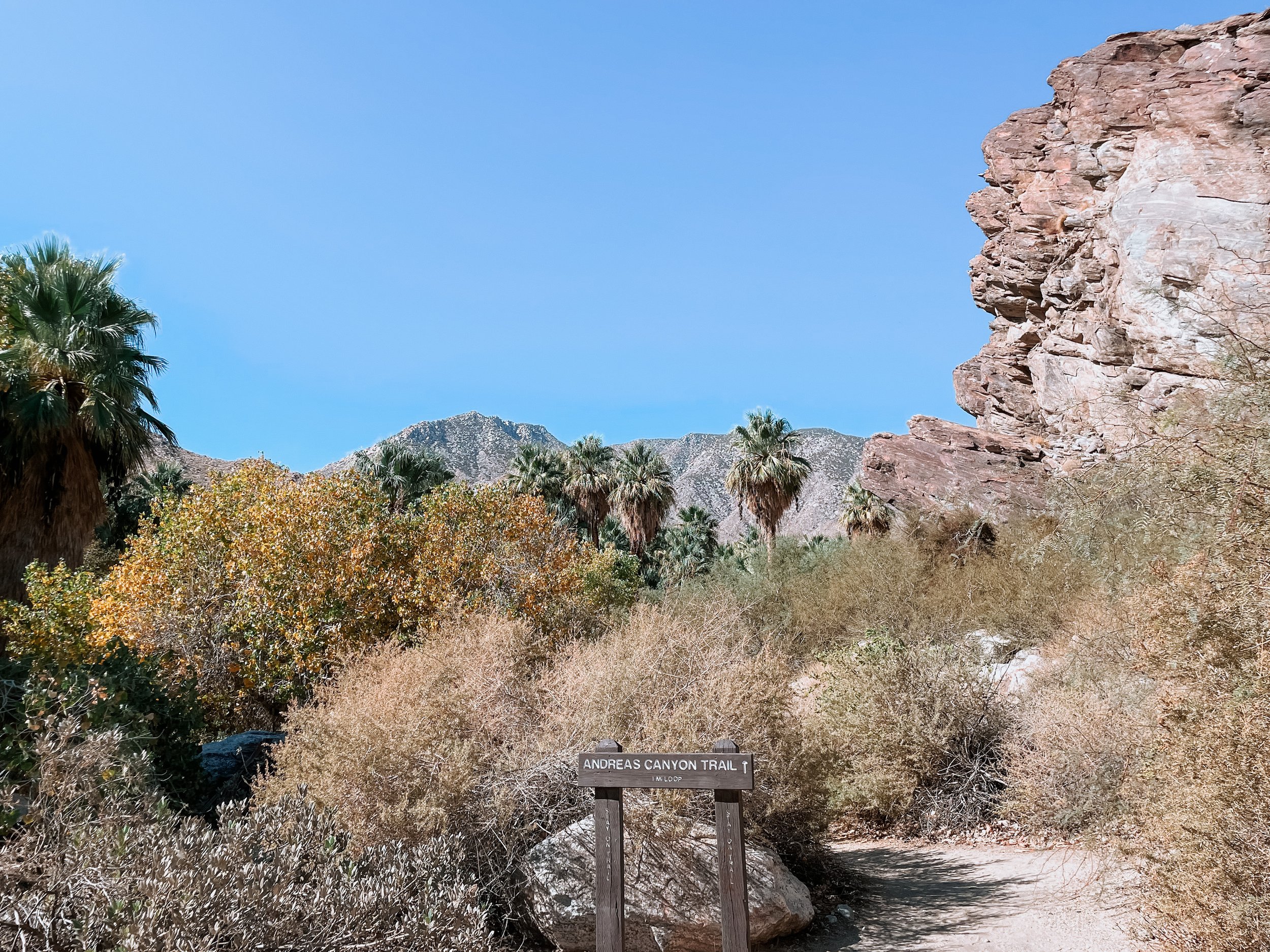
Andreas Canyon Trail
This hike is located in Indian Canyons which is the ancestral home of the Agua Caliente Band of Cahuilla Indians. You have to pay for entry into this area and that allows you access to Andreas Canyon, Palm Canyon (more info below), and Murray Canyon (located in the same parking area as Andreas Canyon). There are so many hikes that you can do here so it’s a great place to choose a few to do in one day.
This trail has a little bit of everything! Mountain views, palms, and a stream that runs along part of the trail (except in summer). Starting at the unpaved parking area, you can begin the trail loop in either direction (we went counterclockwise). This takes you past some unique rock formations on the right and the rows of palms lining Andreas Creek to the left. The trail is partially shaded, so keep this in mind if you visit on a hot day. During the summer, I recommend starting any of these hikes early. Following along the stream, you will encounter a few stone steps and a short wooden bridge to cross over and continue the loop (not accessible for everyone). You then reach a clearing and will be hiking out of the canyon where you’ll be surrounded by mountains views in the distance. From here, you will have Andreas Canyon on the left and eventually the trail will lead you back into the palms and back to the trailhead.
About the trail:
1.0 mile (1.6km) loop
Difficulty: Easy
Time: ~30min
No dogs allowed
Fee: $12-$15 entry per person

Andreas Creek


Tahquitz Canyon Loop Trail
Tahquitz Canyon is also part of the Agua Caliente Band of Cahuilla Indians reservation land, but it is in a DIFFERENT location to Indian Canyons and has a separate entry fee. The Tahquitz visitor center has a small display of artifacts and exhibits to learn more about the history of the canyon and the people that lived here, this is where you will enter through to pay the entry fee and begin the hikes.
Waterfall in the desert? Yes! Well sometimes. This short trail in Tahquitz Canyon leads to a beautiful 60ft waterfall that some people even swim in! The best time to go to see the waterfall flowing is in the winter months or after a rainfall and the best months in general to hike in Palm Springs is October to May. It’s a beautiful hike even when the falls are dry. Along the trail, you can find rock art and ancient irrigation systems that show how the canyons were used. This hike does not have shade.
About the trail:
1.9 mile (3km) loop
Difficulty: Easy
Time: ~1hour
Elevation Gain: 328ft
No dogs allowed
Fee: $12-$15 entry per person

Palm Springs view from Tahquitz Canyon on an overcast day
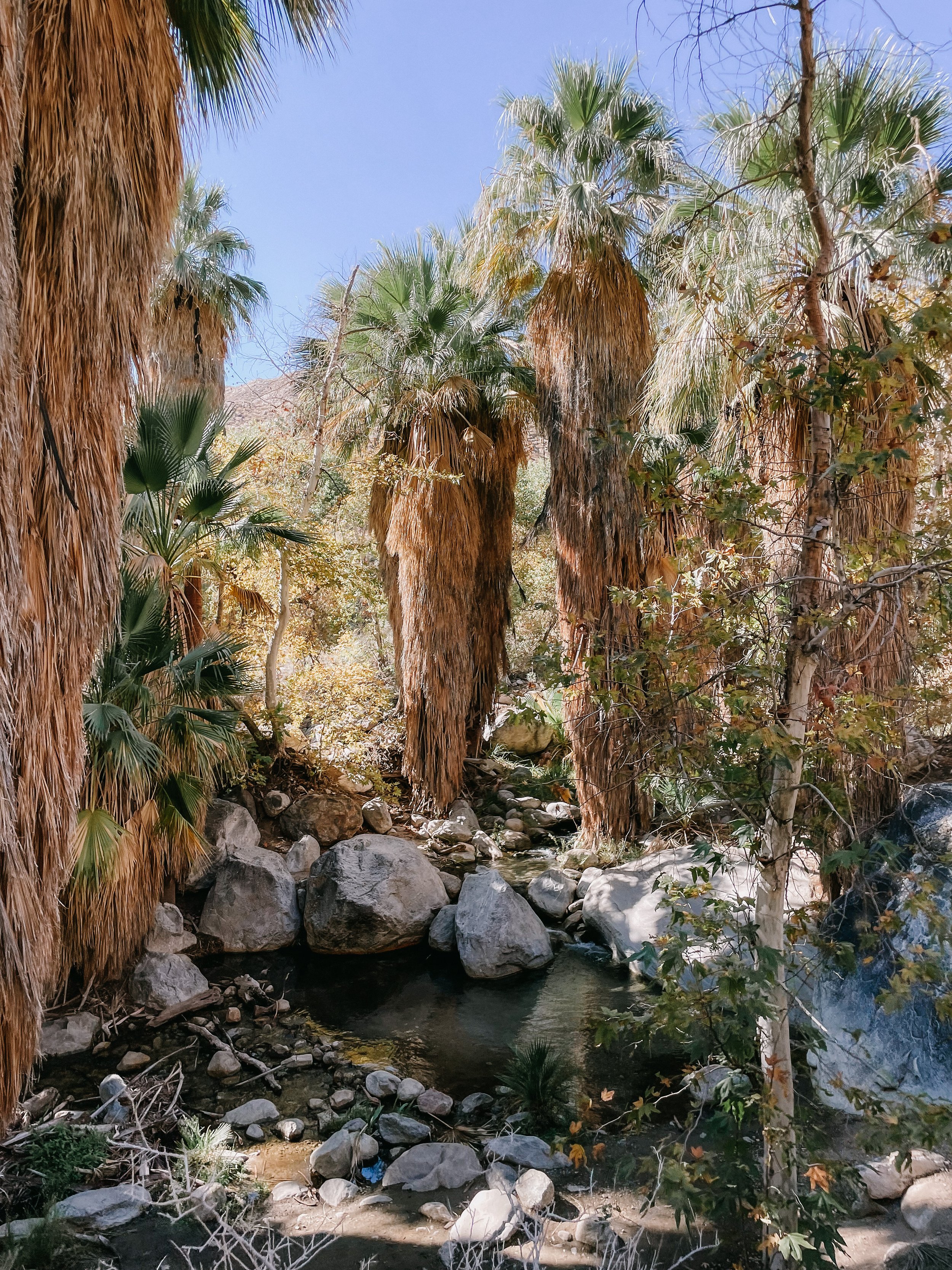
Palm Canyon Trail
This hike is located in Indian Canyons which is the same location as the first hike we mentioned (Andreas Canyon Trail). I highly recommend combining this hike with another in the Indian Canyons area to make the most of your entry fee. This means hikes in Palm Canyon, Murray Canyon and Andreas Canyon.
If you’re looking for Instagram/Pinterest worthy photos during your Palm Springs trip, this is the hike for you! You don’t need to go far into this hike to get to the palms, but if you do continue on and complete the trail you’ll get a relaxing shaded hike amongst the dreamy palms oasis. The beginning of this hike takes you down a relatively steep slope but then it’s mostly flat the rest of the hike. Once you’re in the canyon, you can wonder around the unique curving palms and take your time by stopping at one of the picnic tables that are dotted around the trees. You can make this trail longer by taking the West Fork Trail on the right when you reach the sign, or go left to complete the 2 mile hike.
More info about Indian Canyons here.
About the trail:
2.0 mile (3.2km) out-and-back
Difficulty: Easy
Time: ~1hour
Elevation Gain: 300ft
No dogs allowed
Fee: $12-$15 entry per person

Beautiful palms oasis!


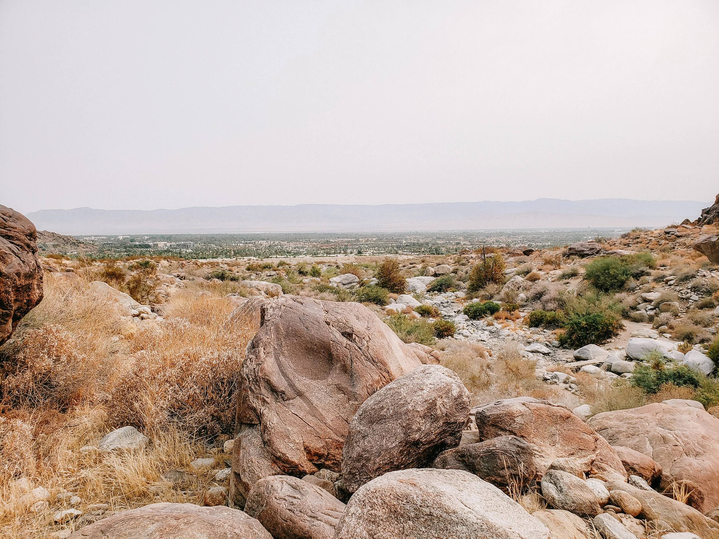
Simonetta Kennett Viewpoint via South Lykken Trail
This hike in Palm Springs is located near the entrance of Indian Canyons and is completely free! There’s plenty of street parking nearby, but it can get busy on some weekends.
This trail takes you up in elevation to get some beautiful views of the surrounding areas and the mountains. You start and finish the trail by climbing some relatively steep switchbacks up to the top and from there you can just soak in the views or continue further onto other trails before returning back the same way you began. This trail is not shaded.
About the trail:
2.1 mile (3.4km) out-and-back
Difficulty: Moderate
Time: ~1hr15min
Elevation Gain: 600ft
No dogs allowed

Pink cactus with snowy mountains views in the distance


San Jacinto Peak
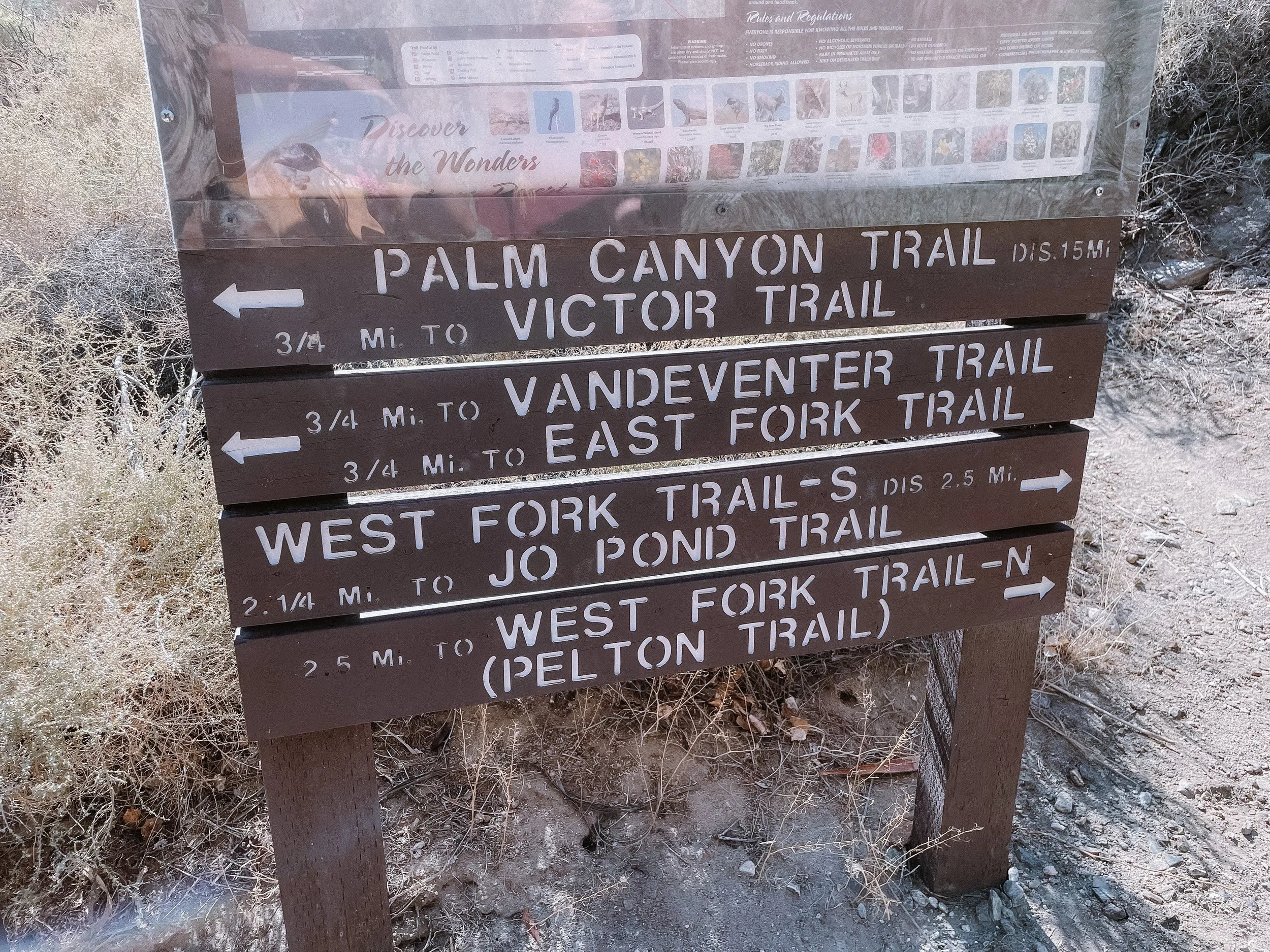
For those wanting a full day of hiking and outdoors, this is the place for you! Located just outside of Palm Springs, Mount San Jacinto is the beautiful mountain that can be seen as the backdrop in almost every view of Palm Springs. You can climb to the peak of this 10 834ft (3 302m) tall mountain on a day hike or even camp in Mount San Jacinto State Park to spend more time on the mountain. San Jacinto does get snow in the winter so the best time to do this hike is April through November but you can also do this hike in the snow if you’re prepared for this. Both routes are partially shaded.
The first (and probably most popular) way to hike to the peak is via the Palm Springs aerial tramway. This means taking the tramcar up to the Mountain Station and then beginning the hike from the trailhead there. The trail starts with switchbacks on a paved pathway that leads you down to the forest area. From here, you’ll be ascending until you reach the top with some rock scrambling at the very end which can be challenging for some. Taking the tramway provides amazing views on the way up and if you don’t have time for the full hike, you can follow the trail for a few miles into the forest before turning around and enjoying the restaurants, views and gift shops at the top of the tramway.
A free permit is required for Mount San Jacinto State Park (both hikes below) which you can get online here.
About the From The Tramway trail:
10.0 mile (16km) out-and-back
Difficulty: Hard
Time: ~5hr30min
Elevation Gain: 2 555ft
Fee: $30 per adult for tramway ticket, you can buy online here.
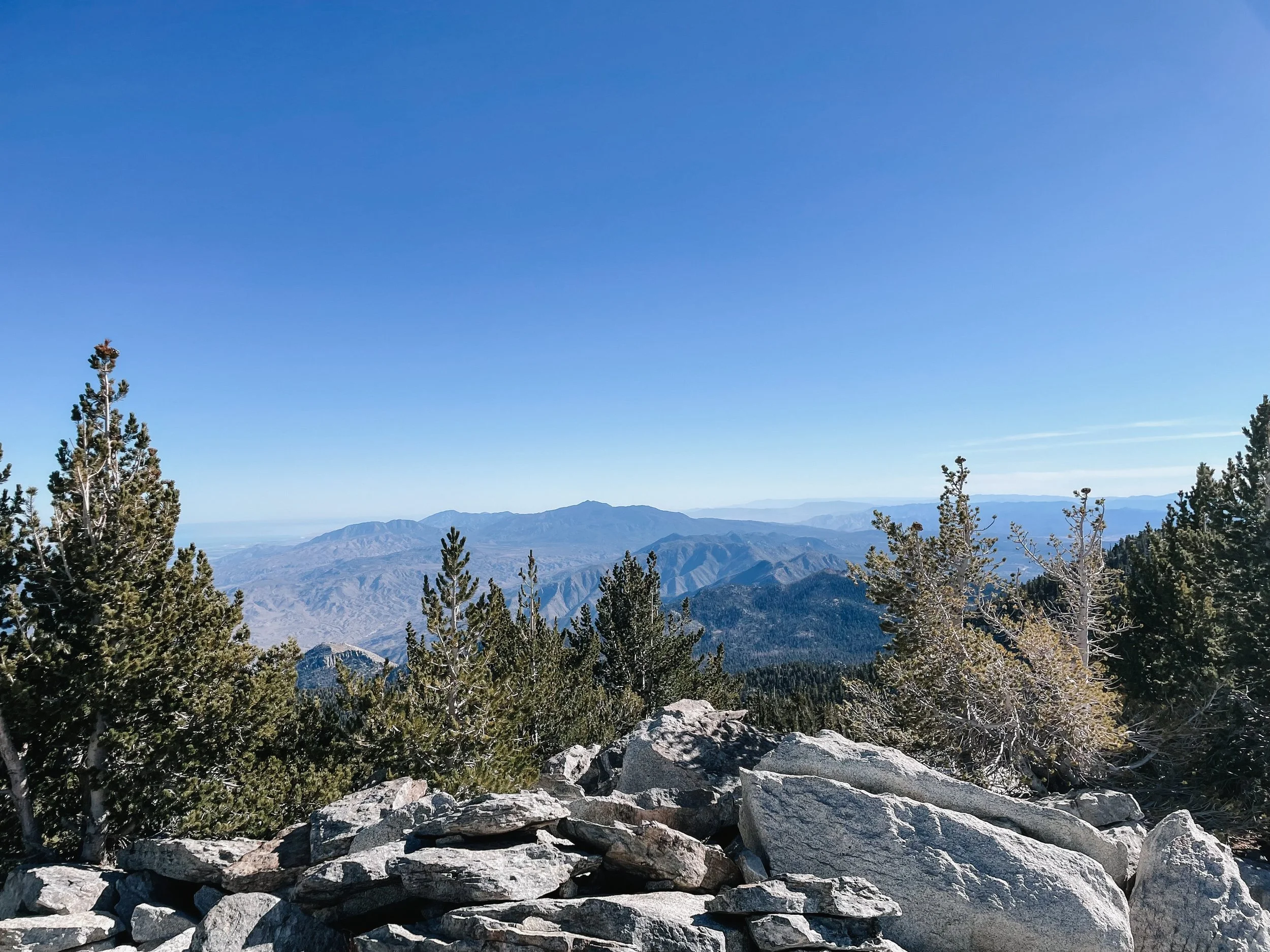
Clear blues skies and views of Palm Springs and the other desert cities
The second option involves driving further away from Palm Springs up to Marion Mountain campground where you will park. This hike to the peak takes you through the pine forests that live above the desert and is one of our favourite hikes in Southern California! It is definitely challenging and not recommended for casual hikers, but the views at the peak are beautiful regardless of the route you take. On clear days, you can even see out to the Pacific Ocean!
About the Marion Mountain to Peak trail:
11.2 mile (18km) out-and-back
Difficulty: Hard
Time: ~8hours
Elevation Gain: 4 452ft

We made it!


Did you find this travel guide useful? Save this pin to your California Travel board on Pinterest!


